


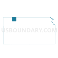
Cook Township Voting District, Decatur County, Kansas
About
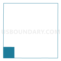
Outline

Summary
| Unique Area Identifier | 584472 |
| Name | Cook Township Voting District |
| County | Decatur County |
| State | Kansas |
| Area (square miles) | 35.90 |
| Land Area (square miles) | 35.87 |
| Water Area (square miles) | 0.03 |
| % of Land Area | 99.92 |
| % of Water Area | 0.08 |
| Latitude of the Internal Point | 39.60438600 |
| Longtitude of the Internal Point | -100.67558960 |
Maps

Graphs
Select a template below for downloading or customizing gragh for Cook Township Voting District, Decatur County, Kansas


Neighbors
Neighoring Voting District (by Name) Neighboring Voting District on the Map
- Achilles Township Voting District, Rawlins County, KS
- Bassettville Township Voting District, Decatur County, KS
- Jefferson Township Voting District, Rawlins County, KS
- Prairie Dog Township Voting District, Sheridan County, KS
- Prairie Dog Township Voting District, Decatur County, KS
- Summit Township Voting District, Decatur County, KS
- Wendell Township Voting District, Thomas County, KS
Top 10 Neighboring County Subdivision (by Population) Neighboring County Subdivision on the Map
- Prairie Dog township, Sheridan County, KS (76)
- Wendell township, Thomas County, KS (57)
- Achilles township, Rawlins County, KS (46)
- Prairie Dog township, Decatur County, KS (38)
- Jefferson township, Rawlins County, KS (37)
- Bassettville township, Decatur County, KS (35)
- Cook township, Decatur County, KS (24)
- Summit township, Decatur County, KS (13)
Top 10 Neighboring Unified School District (by Population) Neighboring Unified School District on the Map
- Oberlin Unified School District 294, KS (2,808)
- Rawlins County Unified School District 105, KS (2,108)
- Golden Plains Unified School District 316, KS (790)
Top 10 Neighboring State Legislative District Lower Chamber (by Population) Neighboring State Legislative District Lower Chamber on the Map
Top 10 Neighboring State Legislative District Upper Chamber (by Population) Neighboring State Legislative District Upper Chamber on the Map
Top 10 Neighboring 111th Congressional District (by Population) Neighboring 111th Congressional District on the Map
Top 10 Neighboring Census Tract (by Population) Neighboring Census Tract on the Map
- Census Tract 9506, Rawlins County, KS (2,519)
- Census Tract 9534, Thomas County, KS (1,982)
- Census Tract 9526, Sheridan County, KS (1,221)
- Census Tract 9511, Decatur County, KS (1,104)